Cascadia Fault – Mega Earthquake Looms Off Pacific Northwest

The Cascadia Subduction Zone
The Cascadia subduction zone runs seven hundred miles off the coast of the Pacific Northwest. It starts at the northern end of California near Cape Mendocino, runs up the entire length of Oregon and Washington, and continues to at least the middle of Vancouver Island, Canada.
The “Cascadia” part of its name comes from the Cascade Range, a chain of volcanic mountains that follow the same course a hundred or so miles inland. The “subduction zone” part refers to a region of the planet where one tectonic plate is sliding underneath (subducting) another.
What is a Subduction Zone?
 Tectonic plates are those slabs of mantle and crust that, in their epochs-long drift, rearrange the earth’s continents and oceans. Most of the time their movement is slow, harmless, and all but undetectable. Occasionally however, at the borders where they meet, it is not.
In a subduction zone, one tectonic plate bends and slides beneath another, returning back into Earth’s mantle (the hotter layer beneath the crust). The biggest danger of a subduction zone is that they can cause massive, catastrophic earthquakes.
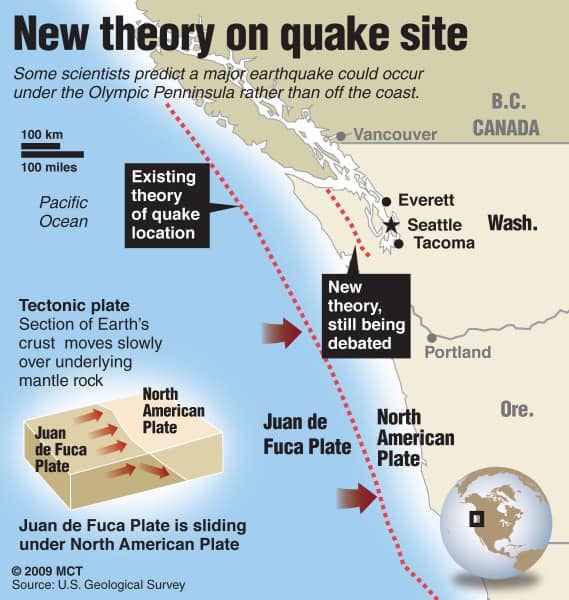
Why do subduction zones cause the biggest earthquakes? The answer is a simple one: scale. The Cascadia Subduction Zone, for instance, runs for 620 miles along the Pacific Northwest. The Juan de Fuca plate is slipping steadily beneath the northwestern portion of North America. The sheer scale of the zone means that when an earthquake occurs, it’s likely to be massive. Think of how much energy is being released along a fault the length of 620 miles!
“The Really Big One”
In 2015, The New Yorker Magazine came out with an article titled “The Really Big One” in which author Kathryn Schulz discusses what will happen when a massive earthquake hits the Pacific Northwest.
In this eye-opening article, she states: “In the Pacific Northwest, the area of impact will cover some hundred and forty thousand square miles, including Seattle, Tacoma, Portland, Eugene, Salem (the capital city of Oregon), Olympia (the capital of Washington), and some seven million people. When the next full-margin rupture happens, that region will suffer the worst natural disaster in the history of North America.”
You may think this is an exaggeration, but it’s not. Consider the following:
- Hurricane Katrina (2005): 1,800 fatalities
- San Francisco Earthquake (1906): 3,000 fatalities
- Hurricane Maria (2017): 3,000 fatalities
- Hurricane San Ciriaco (1899): 3,300 fatalities
Experts believe that when the Cascadia Subduction Zone finally ruptures, an estimated 13,000 people will perish. This includes estimates for both the damage the earthquake will cause and for the resulting tsunami. The more time goes on and the more populated the area becomes, the more this estimate will rise.
How Big Will “The Really Big One” Be?
In order to understand this question fully, we have to understand how the strength of earthquakes are measured. Scientists use the Richter Scale to measure earthquake strength, starting at 1 at the weakest and 10 at the strongest.
Each level of the scale is ten times stronger than the previous. That is, a magnitude 2 earthquake is ten times stronger than a magnitude 1 earthquake. A magnitude 3 earthquake is one hundred times stronger than a magnitude 1 earthquake.
A sizable earthquake is generally one that is 6.0+ on the Richter Scale. A big earthquake is considered in the 7.0 area while a massive one is 8.0+ magnitude. Knowing this, let’s take a look at some of the biggest earthquakes in history:
 Mexico (2017): 8.2 magnitude
- Chile (2015): 8.3 magnitude
- Peru (2001): 8.4 magnitude
- Indonesia (2005): 8.6 magnitude
- Indonesia (2004): 9.2 magnitude
The Cascadia Subduction Zone can have smaller earthquakes that originate in the crustal faults near Mt. Rainier. These might be in the 7.0 range. But when the subduction zone ruptures, it’s estimated that it’ll be in the 9.0 range. The last time the Cascadia Subduction Zone had a big quake was in 1700.
There is some debate over where exactly the quake will originate. Some scientists think that the earthquake could start under the Seattle-Tacoma area rather than out in the Pacific (Blumenthal, 2009).
Why Will “The Really Big One” Cause So Much Damage?
The answer to this question lies in the fact that Seattle is a heavily populated urban metropolis that is built in a seismic hazard zone. Roughly 720,000 people live in the city of Seattle and many parts of the city are at high risk for strong seismic activity.
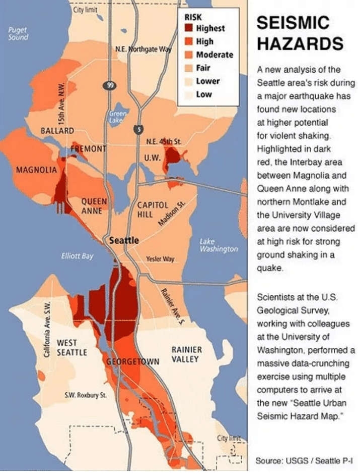
With so many people living in such a seismic danger zone, the disaster is sure to be catastrophic, hence why people should already be preparing for when the really big one hits. Click here to see our earthquake preparedness checklist and make sure your family will be safe.
What Will Happen When the Big Earthquake Hits?
 While scientists aren’t positive on what will happen when the big one hits Seattle, they have a good idea based on previous quakes from around the world.
Likely, there will be some seismic activity before the quake, perhaps in the form of smaller quakes or rumblings in the deep. We still don’t have the technology to predict exactly when an earthquake will strike so you may only get a few minutes of warning — or no warning at all.
When it strikes, there will be intense shaking for a long period of time, perhaps up to a few minutes, before the movement subsides. When it ends, the slow distortion side (the Washington/Oregon side) will have flattened and lowered the west coast by up to six feet.
Around 15 minutes later, a tsunami will strike the Pacific Northwest’s coast with waves ranging from twenty to one hundred feet high, depending on how strong the quake was.
Damage to people and property will be immense and older, less structurally sound buildings will have collapsed. Emergency services will be overwhelmed and there will be a good deal of panic for hours, if not days.
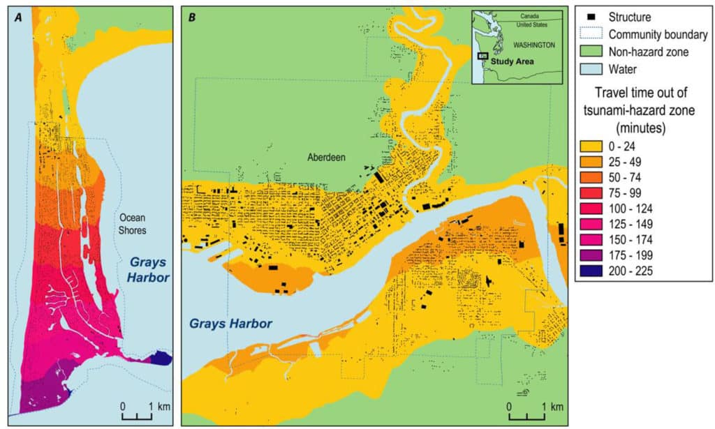
That tsunami will wipe Clatsop’s coast clean. Below, while it isn’t Clatsop, is a tsunami simulation of how just one coastal community (Ocean Shores) in Washington state will have no time to evacuate. On top of that, the land around Ocean Shores is lower than the expected tsunami height.
What is the Probability of a Big Earthquake in the Cascadia Subduction Zone?
You’re probably asking yourself, “How worried should I be really?” It’s a fair question to ask, but make sure that you understand that the question isn’t if the earthquake will hit but when. It’s going to happen. It might be today, it might be tomorrow, it might be 20 years or 40 years from now… but it’s going to happen at some point.
Here are some emergency items that might help you survive a big earthquake:
This is an emergency radio that is essential for any emergency or disaster. It can be recharged through its solar panel, hand turbine power generator, or built-in rechargeable battery.
This is a document and valuables safe with a waterproof and fire-resistant design for long-lasting use. It features a privacy key lock to keep items safe from prying eyes.
This is a Type II safety can that can hold up to 2 gallons of liquid oil. It is colored green and made of galvanized steel, with a height of 13.25 inches and an outside diameter of 9.5 inches.
Geologist Chris Goldfinger suggests that there’s roughly a 37 percent chance of the really big one hitting in the next 50 years. That calculates to around a 0.002 percent chance on any given day (Runge, 2015).
The takeaway here is that while you shouldn’t worry or fret over the big one hitting, you should be prepared. Make sure you and your family have an emergency kit and an earthquake plan (where to go if you feel shaking).
Can the Cascadia Earthquake Cause Mt. Rainier or Mt. Saint Helens to Erupt?
While it’s possible that a large earthquake may cause the magma beneath Mt. Saint Helens or Mt. Rainier to bubble over, it’s far more likely that the danger will come from landslides instead. There will be massive landslides from the steep slopes and potential avalanches from the snow pack.
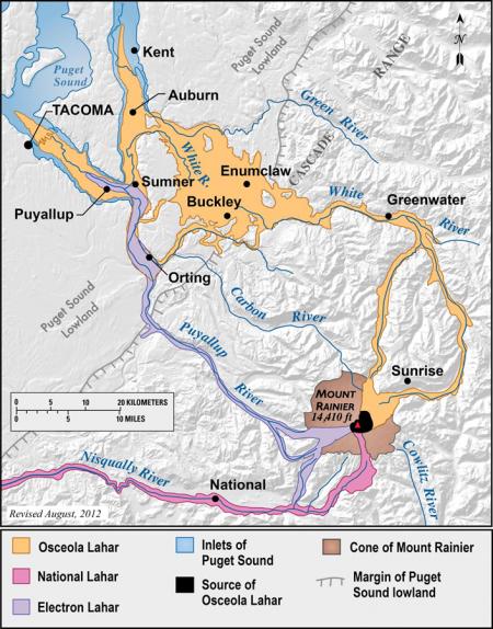
Mt. Rainier has an interior like soft clay which has been formed by the active hydrothermal system beneath the mountain itself. The cycles of freezing, expansion, thawing, and contraction have made the ground there very unstable. Thus, the major threat is from the collapse of a portion of the mountain itself into lahars, or massive mudslide that wipe out anything in their path.
The pathways of previous lahars can be seen below. Anyone living in these danger zones should be acutely aware that a massive mudslide and land flow is possible after an earthquake.
